
Part I (Day 0) – Before the Climb
Part II (Day I – Feb 18) – Aiming for Kabugan Campsite
Part III (Day 2 – Feb 19) – A Surprise at Paray-Paray
The rains continued drizzling all throughout the night and come morning time, strong winds have accompanied us at the campsite. Actually, the rain itself wasn’t that strong during the early morning so when we decided to assault the summit, it was still tolerable. That quickly changed as we went higher and higher up Mt. Mantalingajan especially once we hit the open trails that lead up to the summit.
Before the whole business of Typhoon Crising, we wanted to conduct our summit assault very early, early enough to catch the sunrise at the peak. When we brought it up with Tay Dinio, he warned us not to do so because of the dangerous trail that we’d have to take. He also said that those dreaded snakes were more active during the night so it would be wise to postpone it a little, when the sun was already up. Binoy kindly chided that even though most mountaineers who have scaled Manta always ask him about the supposed snake-infested trail, he has never encountered one before. He admitted that there were snakes, and a lot of them at that, but in all the years of guiding, he has never come across one during a climb before. Tay Dinio was a different story though and he was quick to recount the tale of campers where a snake suddenly joins them around their campsite and even slithers on the feet of one of the climbers. Being the one in the group with an irrational fear (and sometimes hatred) of snakes, I appreciated the warnings that Tin and Fred gave Tay Dinio to not talk about it too much when in my presence lest I lose all my calm and panic while balancing precariously on a trail that doesn’t look like it’s meant to be crossed by humans (logic in mountains suggest that it, in fact, was not).
In any case, we woke up at about 4 (someone was already redeeming himself to cook breakfast at the ungodly hour of 3 AM…) to get ready and eat our breakfast before we headed up to the summit at about half past 5. Sir Mayo told us that a summit assault would take at most 4 hours even at a generous pace but I guess he wasn’t accounting the fact that we were going to do it amidst a tropical storm signal since it took us almost 5 hours before we were safely back at the campsite again.
The first part of the assault (right after the campsite) was a steep ascent via boulders that were slippery because of the rain and bonsai trees that were also quite hard to hold on to. We were still wearing our headlamps by then but it was still clear that the trail was ridiculously dangerous as any “knife edge” that we’ve ever trekked on or heard about. Tin would later tell us that seeing Fred being swayed by the strong winds or losing sight of me while trekking (I was trekking behind her and would sometimes stop to tie my water bottle properly or else, take pictures), she had half a mind to cancel the assault altogether. She said that the G2 trails can’t even hold a candle to the difficulty of that initial assault and night trekking it no less, was probably an insane decision. But, we were never without caution so we safely survived that trail and the eventual ridge it led to despite our various trepidation.

early AM summit assault

the ridge
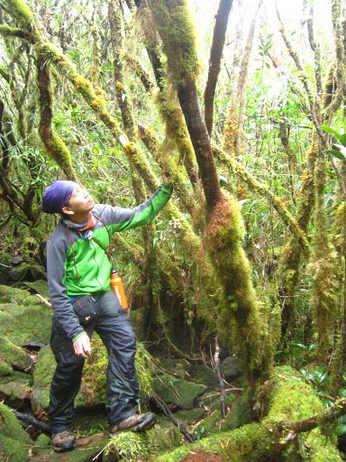
After that death defying ridge, we arrived at a lush mossy forest that rivals those that can be found at Mt. Tabayoc. By then, the sun (we assumed…since we couldn’t actually see it because of the clouds) had already risen so we had ample light to navigate the forest and be amazed at its beauty. It was really a sight to behold and the lushness of the mossy trees gave it an eerie feel. This would continue on for the better part of the hour among paths that were steep and also not wide enough to be entirely comfortable in. We had to constantly contort ourselves just to be able to break through the thick vegetation that was obstructing the ‘trail’. For this part, at least, the forest offered enough shelter against the strong winds and the steady pouring of the rain.

mossy forest

the initial part was wide enough but after this area, the trail gains elevation and becomes almost non-existent until we break the forest line
moi!*
At about 6:40, we finally broke through the forest line and started walking the tree-canopy trail that would lead all the way to the summit. By here, we had nothing to shield us from the elements anymore so we had to endure the ridiculously heavy winds and the constant patter of rain against our faces. It even got to the point where Fred had to lend his jacket to Binoy, who was not that used to the coldness of the weather since he (Fred) was better adapted for it. Binoy said that the last time that he guided mountaineers through similar weather; the group gave up about halfway to the summit and just decided to hike back down. Admittedly, he said that the rain was much stronger then but the winds were not as harsh. For us, the conditions were reversed. The rain was very light but the wind was unforgiving. So we had to be very careful because the trail to the summit was no laughing matter.
At this point, the pictures would be deceptively easy when the fact of the matter is that it was dangerous and very annoying too. At first sight, you’d think that all it would take is to walk with simple gait to reach the destination. But upon closer examination, you’d find yourself bereft of even the smallest clump of soil to steadily stand on. Instead, we spent the next hour scrambling for a stable foothold among the slippery rocks or else test the sturdiness of the branches that were in front of us. There were many crevices in between rocks so you’d have to be very cautious about where you’re stepping on and what you’re holding on to. We realized an amateur moment of not bringing gloves during the climb because we were left to deal with the sting of holding on spiky rocks because that was the only way you could haul yourself forward. If you held on too tight, you’ll draw blood. And I wish I was kidding but I’m not (this was based from actual experience…). Adding the fact that they were dripping wet, it really made the assault all the more nerve-wracking and dangerous. After an hour of this, we finally reached the summit.

you’d think all you had to do was walk…

I honestly wished it was so

vertical ascent

Tin en route to the summit

Fred as the sweeper. During the descent, he was our lead man for the most part

most times, it hurt just as much to hold on to the rocks

a very cold Binoy in the background hehe
I really can’t describe the feeling of reaching the summit of Mt. Mantalingajan enough but heck I will try. It was so emotional because the fact that we summited one of the hardest mountains in country began to sink in. At the back of our minds, we hoped that we were given better weather to enjoy the clearing and the majestic view that were we sure Manta had but it was, in no way, enough to create any disappointment in us. We good-naturedly said that at least it gave us motivation to come back to our beloved Manta next time. 😀 We were excited, proud, awed, humbled and everything else in between. We really couldn’t believe it. And if you see us in person, you probably won’t believe it either.

Manta summit! with nothing but fog in the background hehe

a dug hole that marks the summit, Binoy said that it was done by treasure hunters

with our guide, Binoy na kahit lamig na lamig na, nagawa pang mag-ok sign hehe

Manta summiteers wohoo!!*
We offered the Climb Against Cancer prayer atop Mt. Mantalingajan and while reciting the prayer, I would admit that I cried. And I’m not saying I was holding back a tear or two, no. It was frakin’ streaming. It was the internalization of the intent of the CAC prayer and the fact that I was atop Mt. Mantalingajan combined that brought on the tears. I could hear Tin was crying with me although Fred had more sense to not be too obvious about it. We probably shocked Binoy with our tears and probably planted doubts in his mind about the states of our sanities.

after the tearful prayer with Fred ‘modelling’ the CAC bagtag*
It was about 8:10 when we finally said goodbye to the summit of Mt. Mantalingajan and after another two hours of navigating the ‘trail’, we were back at the campsite. We saw glimpses of the landscape surrounding the summit on the way down and the sheer danger of the ridge that we crossed earlier now that it was bright enough. All the while, we felt proud of the fact that half of the hardship was over and whatever anyone else may say, we were able to reach the summit of the famed Manta and survive it. With that confidence brimming inside us, we excitedly started our journey to continue this climb and take on the traverse. In retrospect, I would say that the tears we shed were wholly premature. We should have reserved it for the coming days.

Binoy showing Fred where Paray-Paray was*

view on the way down

Fred, the tiny orange dot hehe


the ridge by daylight*

by this time, the rain was steadily getting stronger that I had no choice but to put the cam away
We left Paray-Paray after having lunch, sometime around 12 noon to reach our target for the day which was Lapong campsite. We initially intended to leave earlier but since the weather wasn’t all that favourable, we decided not to rush ourselves on the descent. Tay Dinio kindly went and fetched water while we were at the summit so we had enough to precook our dinner fare before we left Paray-Paray. He told us that since it was already noon, we should consider the possibility of not reaching Lapong in time and advised us that wherever we were by 6 in the evening, we should make camp since night trekking at that part of the trail was highly inadvisable. We decided to defer to his suggestions again but still resolved to reach Lapong, if we could, by the end of the day.
From here on out, the rains became much stronger that what it was during our summit assault so I decided to safely tuck away my camera inside the bag for safekeeping. Which was why we had no more pictures during the latter half of the third day all up until the afternoon of the fourth day because the rain didn’t let up until then. So whatever else happened, you just have to take my word for it. 😀
I have been more than clear that the traverse side of Manta was way harder that the traditional route. Sometimes I wished that I was exaggerating this but sadly, I am not. After Paray-Paray, the trails became much more compact and steep than ever before. By this time, soil was basically unheard of. All you had to content yourself with were trees and rocks. The first part of the trail opened up to the mountainside which I’m guessing had breath taking views if the weather cooperated. But during that time, all that was foremost in our minds was how to survive the next step.
As we descended to Tabud River (our first landmark), the trail became solely consisted of mossy rocks and fallen branches. Every step we took came with the danger of falling to the pit in between the huge rocks. Binoy said that they were not deep enough that you’ll be lost and never be heard from again but a slip would definitely break a few of your bones and probably leave you incapacitated. And since we were at least one and a half a day away from the nearest hospital; that was clearly not an ideal scenario.
Tin would also later tell me that aside from fearing for her life, she also feared the snakes that were most likely residing in those crevices but since one misstep could have fatal consequences, she didn’t make any remarks in my presence. I was grateful for that fact although to be honest, I may have pushed it at the rear part of my consciousness because I didn’t think about (or subconsciously chose not to) snakes at all. All I thought about was how I was going to survive the next step. There was one particular section where I had to vertically hug a slippery rock and hope against hope that the leg I was blindly stretching would catch on a foothold that I could not see. And again, I wish that it was a ‘one part of the trail’ kind of thing. But no, this type of trail continued on for the whole duration until we reached our first break at Tabud River which we reached after an hour.
Tabud River dispelled any doubts we had about the fact that we were cursed. Because like the Paray-Paray campsite, the river was dry. In the middle of a tropical storm. And this wasn’t some little stream or whatever. No, it was a frakin’ proper huge boulder-encrusted river! By then, we didn’t know what to do because I remembered the note that was printed on our original itinerary that said:
– Tabud River, lunch, load lots of water *LAST WATER SOURCE –
Tin even capitalized the section for heavy emphasis. Hehe I guess it was a boon as well as a bane that Typhoon Crising was with us. We ended up stopping a little farther down the trail when we were on sturdier ground to stop and collect pouring water from leaves to replenish some of the containers that we have already depleted. Farther along the trail, Tay Dinio located a smaller stream which had running water on it so we finished our water-collecting there. To give you an idea how fickle the conditions in Mantalingajan is, during their usual climbs, Tay Dinio and Binoy said that the spot where we fetched water usually did not have any which was why the only water source stated in all of the past itineraries was Tabud River. But since the universe had it in for us, I think she decided to switch it up a bit just for fun.
So we were able to continue our journey to Lapong with all of us lugging around a minimum of 5 liters as well as wet tall packs. With full packs like that, you’d think that we’d be generous with breaks during that descent but seeing as it was raining hard, we hardly took any breaks from trekking at all. After all, it would be more uncomfortable and the break in motion would leave us feeling cold so we feared that it would be more hurt than actual help.
After Tabud river, the death-defying trail continued for the better part of the afternoon. Binoy assured that it would be ‘easier’ after a while although we realized that this meant just a different type of trail but probably as dangerous as any part of the traverse. At one point, we came across our first solid patch of soil where Binoy jokingly said, “Sabi ko sa inyo kuya eh, makakatikim uli kayo ng lupa.” I literally hopped like a little child when we got there…never minding the fact that it stretched to a mere 50 meters or so before the trail resumed its ‘boulder and fragile broken trees combination’ trait.
It was late in the afternoon, about 4 or 5 I think, when the trail finally let up and gave us solid soil to walk on again. But even then, the discomfort did not stop. By then, the overgrown plants became standard in the trail that we found ourselves being constantly whipped with vines as we hauled ourselves using fragile trees across soil that was slippery because of the rain. And they weren’t some harmless vines either. They were the thorny ones that we, Tagalogs, call ‘uway’. Most of the trail from here on until well into the fourth day was laden with these thorny bastards. And they had different kinds too. They had so many varieties that the Pala’wans have different terms for it. They call the usual little ones ‘timbarangan’ while the huge ones that could pierce you if you mistakenly grip it for support were called ‘diplak’. Other varieties included the ‘maruwa’ which was a little smaller than the diplak and many others that Binoy pointed out but I wasn’t able to remember. On my own, I was already hating them with a vengeance. And since we had no gloves, we ended up with so many scratches and bruises all along our arms and legs that by the end of the climb, we really looked like we came out on the losing end of a one-sided knife-fight. I kid you not dear reader, I kid you not.

bruised and scarred…kaunti pa to actually

a particularly long cut after an unexpected ordeal with a stray timbarangan
By the last hour or trekking, we were really just relying on sheer willpower to keep us going. Tin was ready to cry, I got irritated every time I saw an incline (yes, it was never ‘descent’ all the way) and cursed every rotten vine that added scratches to my already scarred body. Every step seemed like an eternity and every movement was such a chore. Binoy would later tell us that he almost found the way we looked as amusing and a little surprised that we didn’t end up giving up . 🙂
At about a quarter to six, Binoy informed us that we were very near Lapong campsite and we may very well reach it with plenty enough light. This gave us renewed strength (I use the term loosely, we were just as tired as ever…) and true enough, just as light was waning, we reached Lapong campsite at about 6:15 PM. After resting for a bit without minding the constant rain anymore, we quickly set up camp, arranged our cooking station and began preparing our dinner as well as next day’s meals. We huddled around the butane-fueled “campfire” while collecting water from the rain to use for hot beverages and even soup. In a way, it was also a good thing that it rained because despite Manta being a little too greedy with its water sources, the sky ended up giving us plenty.
Despite the weather, we still enjoyed telling each other stories around the campfire until it got late enough to call it a night. We all felt excited about our final day because it was the last day of the climb and if we’re successful, we’ll finally be able to clear the hardship known as Mt. Mantalingajan. But still, our anxieties never left us because the last day would be the longest trek yet and the trails were pretty much the same (and a whole lot more as we found out…). Add the fact that we slept through a very stormy night that at some point, we kept fearing that our tent could not stand up to the heavy winds that were beating it from without, it really made for a memorable night. In any case, we still felt proud of ourselves that so far, we were able to hit all of our campsites without unnecessary risks (i.e. night trekking and taking e-camps) and although the day was less than ideal, all of the mishaps were clearly out of our control. So even though we were dead-tired, we ended the third night in high spirits. 😀

lone pic of the guys at Lapong campsite. I took it while I was changing out of my wet clothes inside Fred’s tent
Part V (Day 4 – Feb 21) – Final Day
Photo credit:
*Tin Tinio

Pingback: Mt. Mantalingajan Traverse: Before the ‘Climb’ | the fine line
Pingback: Mt. Mantalingajan Traverse Day 1: Aiming for Kabugan Campsite | the fine line
Pingback: Mt. Mantalingajan Traverse Day 2: A Surprise at Paray-Paray | the fine line
Pingback: Mt. Mantalingajan Traverse Day 4: Final Day | the fine line
Pingback: Palawan Redux: Mt. Thumbpeak Outreach Climb | the fine line
Pingback: A Climb Most Memorable: Mt. Victoria (2,010+ MASL) | the fine line